Well after nine days of complete relaxation and slobbing about we arrived back in Papeete again. This time the weather was a lot better than about 70 days ago, when they had huge rains and we weren’t allowed off the ship. For this visit we had a 4WD tour booked that took us into the heart of Tahiti Island and into the Papenoo Valley. This tour was our Christmas present from Renae and was well worth the wait. We were in groups of eight and bundled into the back of Landover utes and then taken on some relatively smooth gravel roads into the interior of the island. Some of the scenery reminded us a lot of Hawaii with its sheer mountains rising up. There were lots of small waterfalls all through the Papenoo Valley and several small river crossings that added to the adventure. We had a swim stop that was very nice as the day was a bit warm and humid. On our return to Papeete we then did a walk around the city, found a nice little bar and replaced some body fluids that we had sweated out on our 4WD odyssey. As the ship wasn’t leaving until 7pm we decided to have a meal on shore, so called into the food trucks that are right out the front on the water front and very popular with the locals. We tried some of the raw fish that is favoured with the locals and enjoyed it very much as we hadn’t had some for a long time. After that it was back on the ship and up to the sweets bar for some of that really tasty healthy food.
Papeete fish market
Papeete fish market
Streets of Papeete
Papeete Cathedral
Neat and tidy street lights of Papeete
Very picturesque foreshore of Papeete
Coastline near Papeete
Interesting seaside landscape
Papenoo Valley
Papenoo Valley waterfalls
Our very lively tour guide for the day
Our 4WD transport
The off road track
Papenoo Valley
Papenoo Valley waterfall
Follow the leader through the forest
One of many sacred sites for the Tahitians
River flowing through the Papenoo Valley
Our swimming hole – very refreshing on a hot humid day
Two Tree Island – I just made that up
Coastline looking towards Papeete
Having raw fish for tea with Tye, Terri and their cousins
Having raw fish for tea with Tye, Terri and their cousins
From Puntarenas, it was it was day at sea then the port of Manta in Ecuador. Manta was our departure point for Cusco and Machu Picchu. This was our last big tour form this trip and one of our most anticipated. We were going to be away from the ship for three nights and the schedule was hectic as well, lucky we are both so “fit and healthy”. We left the ship at 09:30 and had a four hour bus ride from Manta to Lima.
The roads from Manta to Lima were a bit dirty in some stages
Small towns all along the road to Lima
Country side was just so green
Common type of housing in the rural areas
They love bog monuments
Rest stop on the road to Lima
The drive to Lima was very interesting and we travelled through some great countryside. Next stop was the airport. After a three hour wait at the airport we finally left and arrived in Lima at around 19:30 and were driven to our hotel for the night. Our first glimpse of Lima was very brief and in the dark.
Our hotel in Lima was very flash
Los Delfines Hotel – very nice indeed
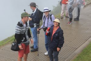
Next morning it was up at 05:30 for a quick breakfast then back to the airport for a flight to Cusco. We arrived in Cusco at around 13:00, put on some buses and taken on a city tour. Cusco is a city of over 300,000 people and the main city you go to for tours to Machu Picchu. First thing most of us noticed when arriving in Cusco and stepping off the plane was the difference in altitude. We were at an altitude of around 13,000 feet and felt a little light headed. Some in our group suffered the difference in altitude quite badly though both Kaye and myself coped fairly well. Kaye bought some small cocoa lollies to suck on which helped while I just did the bloke thing and toughed it out. The tour of Cusco took us around some of the sights and then to the main plaza for a meal at a very nice restaurant and some local food. After lunch we were able to walk around the plaza and then toured Santo Domingo Church and Cathedral. This was one of the more impressive churches we have walked through and was worth the visit. Then only down side was you were not allowed to take any photos. By this stage as well we were starting also to feel the effects of the higher altitude and both really had to slow down our walking pace to be able to breathe comfortably. After our plaza visit it was then on the bus and off to some Inca ruins in the city called Saqsaywaman. When pronounced by the locals it sounds like “sexy woman”, so that’s obviously what we all called it from here on. These ruins were also at a bit higher elevation than Cusco and also were I started to get my first headache. Guess I just didn’t take it slow enough when walking around. The ruins were great to see and walk around and also a great little taster for what we hoped was to come. After touring “sexy woman” it was back on the buses and off to our hotel a bit closer up the road towards Machu Picchu.
Cusco – lots of very old buildings and ruins
Driving through Cusco
Cusco street vendor
Convent De Santo Domingo
Convent De Santo Domingo
Convent De Santo Domingo
Convent De Santo Domingo
Convent De Santo Domingo – fantastic old cobblestones
Convent De Santo Domingo – old Inca gold on display
Convent De Santo Domingo – old ruins on display
Convent De Santo Domingo – park next door
View of Cusco from Convent De Santo Domingo
Cusco has great old style traffic lights
Cusco’s main Plaza
The Plaza
Fantastic old buildings surround the Plaza
Fantastic old buildings surround the Plaza
Fantastic old buildings surround the Plaza
Fantastic old buildings surround the Plaza
Fantastic old buildings surround the Plaza
Fantastic old buildings surround the Plaza
Fantastic old buildings surround the Plaza
Fantastic old buildings surround the Plaza
Entrance to Saqsaywaman – sounds like “sexy woman” when pronounced
For $1US you can take a photo
Saqsaywaman ruins
Saqsaywaman ruins
Saqsaywaman ruins
Saqsaywaman ruins – incredible stone work when you see it up close
Saqsaywaman ruins
Saqsaywaman ruins – people add some scale
Saqsaywaman ruins
Views of Cusco from Saqsaywaman
Views of Cusco from Saqsaywaman
Views of Cusco from Saqsaywaman
The plaza from Saqsaywaman
Drive from Cusco through the Sacred Valley to our next hotel
Approaching the sacred Valley – pretty awe inspiring views
Approaching the sacred Valley – pretty awe inspiring views
Approaching the sacred Valley – pretty awe inspiring views
Old Inca terraces still in use today
Local farmer in the field
At our very nice hotel – Tambo Del Inka
At our very nice hotel – Tambo Del Inka
View from the front of the hotel
After a great night’s sleep in the very luxurious Tambo del Inca Hotel we were back on the buses and off towards Ollantaytambo Fortress for a walk around some more ruins before boarding the train for Machu Picchu. We were staying and driving through what they call the Sacred Valley and is where there are lots of Inca ruins. There are also lots of old Incan terraces along the side of the road that are still in use today for farming. Some of the terraces are still being irrigated with the same system today that was being used all those hundreds of years ago, and that says a lot for the engineering practises of the Incan people. The ruins at Ollantaytambo Fortress are pretty amazing to walk around and offer some spectacular views when you climb up to the top. We were both feeling good as well and felt we had acclimatised quite well to the altitude. My headache had gone and Kaye was happy with a few cocoa lollies to suck on as well. If you are ever in this part of the world the cocoa lollies seem to be as good as anything to help with adjusting to the change in altitude and are available everywhere for about $1.00 a packet. We were able to spend nearly an hour at Ollantaytambo Fortress before we had to leave and go a couple of minutes down the road to catch the train for Machu Picchu. The Fortress is well worth a look at and in some ways has more impressive features than Machu Picchu.
Ollantaytambo Fortress ruins
Ollantaytambo Fortress ruins
Ollantaytambo Fortress ruins
Ollantaytambo Fortress ruins
Ollantaytambo Fortress ruins – there are still fountains working today
Ollantaytambo Fortress ruins
Ollantaytambo Fortress ruins terraces
Ollantaytambo Fortress ruins terraces
Ollantaytambo Fortress ruins terraces
Ollantaytambo Fortress ruins
Ollantaytambo Fortress ruins mountain pathway
Ollantaytambo Fortress ruins grain store higher up in the mountains
Ollantaytambo Fortress ruins working fountains still operating today
Markets next to Ollantaytambo Fortress ruins
The train ride took about one and one half hours to travel the 40 plus kilometres to its destination through some spectacular scenery, then it was back on some buses and a 30 minute bus ride to the top of the mountain and finally Machu Picchu. We seemed to have taken a long time to get here and were both feeling pretty good inside to have finally arrived. Although it seemed crowded when we got to the gate, once we were inside it was only a short walk to the first viewing point and boy was it worth all the effort to get here. The view just knocks you back and it looks just like all the pictures you see in magazines. It had been raining a bit on our way to Machu Picchu but when we got inside and to the first lookout it had cleared up and the clouds were all lifting. Very lucky. It was awe inspiring to just stand there, look and just take it all in. We then walked up to the Guardhouse, this is where all the best shots of Machu Picchu are taken from and what you generally see on posters etc. We had a great guide for the day who was a wealth of information on Machu Picchu and helped make the tour even more interesting. The location and scenery around Machu Picchu is amazing and how they built this place all those years ago without the equipment we have now is mind-blowing. As you walk around Machu Picchu everywhere you look is a photo shot, very easy to spend the day just looking through a camera view finder. As it had been raining before we arrived, you could see the drainage system working around the ruins. This is still the original drainage system the Incas put in as is still working today. They say this is one of the main reasons that helped preserve Machu Picchu. With the earthquakes they get in Peru, they are affecting the stability of the ruins and some parts are roped off as they have sunk slightly. If this keeps happening the talk is that they will have to stop people walking around the ruins and you will only be able to view them from the lookouts, which would be sad if that happens. We spent around three hours at Machu Picchu which was OK though we both would have liked to be able to stay for another few hours and really experience the place. When you are on a tour, your time is in the hands of the operators. It was then back on the buses to the train station and then back to our very flash hotel for dinner before an early get up for the trip back to the ship.
Driving through clouds on our way up to Machu Picchu
Sites you get to go to when you get there
Nearly there – the views were starting to get good
Our first look and luckily the clouds were starting to lift
Everyone was happy to finally make it
Machu Picchu – just incredible
Machu Picchu – just incredible
Machu Picchu – just incredible
Even Alpaca’s up this high to welcome you
Just stunning views
The location is just stunning
Everywhere you look you just take photos
Views are hard to describe
Stunning
Machu Picchu ruins
Machu Picchu ruins
Machu Picchu ruins
Machu Picchu ruins
The mason work was very accurate and neat
Some parts are starting to show the effects of time
Machu Picchu ruins
Views everywhere you walk around
Machu Picchu ruins
Some of the masonry works are incredible to look at
The terraces are so well kept
The block work was amazing
Everywhere you turned there were photos to take
Machu Picchu ruins
Great views in every direction
Incredible to look at
Terraces well kept and so green
Our last look at Machu Picchu on the way out
The river flowing through Aqua Calientes – the town near Machu Picchu
Aqua Calientes markets
Aqua Calientes markets
With Marilyn and Keith at the Aqua Calientes markets
The Cusco Valley
The Cusco Valley
Flying out of Cusco
Flying out of Cusco
The trip the next day was pretty much just a travel day. The drive back through Sacred Valley to Cusco was very interesting, then it was a flight and back to Lima. We had planned to try and have a look around Lima when we got back to the ship but didn’t end up doing so. It was a bit of an exercise to get the shuttle bus into the city and back again and with all the bus travel we had done over the last four days we decided to just chill out on the ship. We are both definitely glad that we have been to and seen Machu Picchu and would thoroughly recommend it to anyone. The location and scale of Machu Picchu is staggering and mind-blowing and is something special to see when you get there. We now have nine days at sea to recover from our little side trip so that means lots of doing not very much by yours truly.
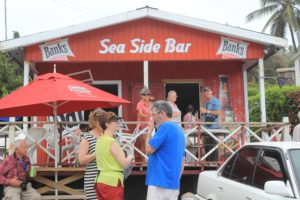
It was nice to have a day at sea again before our next port – Puntarenas in Costa Rica. Not sure why the cruise comes to this port as the ship does seem to go a bit off direction to get here. Not that we really mind though as when you’re just sitting on a ship doing not very much you don’t really care where it takes you. Puntarenas is on a peninsula and only has a population of around 15,000 people. There is not a lot see or do in Puntarenas itself and booking a tour we thought was the best option to take. The only problem is deciding what tour to do. Costa Rica is well known for its forests so we decided on a rain forest tour. The tour also included a gondola ride through the canopy of the rain forest. This was a very easy way to see the forest. After the ride, we then did a short walk around some of the forest and through a live butterfly display. That was quite good though they never stay still enough to allow a photo to be taken. Lunch was provided on this tour so feeding ourselves was easy. Although we enjoyed the tour and the two hour bus ride there and back it probably wasn’t the best one to do. The weather was very warm and as we were there in the middle of the day most animals and birds were all hiding from the heat. An early morning or late afternoon tour of this area would be better. Still we can now say we have been to Costa Rica even though we only saw a small port and bit of a rain forest.
The next day after Cartagena it was the Panama Canal. This was also one of the highlights for us on this trip. The Panama Canal runs north/south which I didn’t know and we were coming from the north. The day started around 06:30 when we got to the entrance to the first lock and finished around 10 hours later when we came out the southern end near Panama City. It is a pretty impressive thing to sail through and to say you have done though it is a bit like watching paint dry as it is a very long slow day. The history of the Panama Canal is quite a story. It was first dreamt of in 1513 when Balboa became the first European to cross the Isthmus of Panama and sight the Pacific. In 1880 the French Canal Company began construction in Panama and were defeated by disease, cost overruns and massive engineering problems. They in turn sold it to the Americans for $40 million which was a $200 million plus loss on their investment. The US began construction in 1904 and completed it ten years later. It was during all the problems that the Americans also encountered on the project that it was taken over by the marine corps that the system of using locks was decided upon instead of the original plan of one level from one end to the other. The US oversaw the administration of the Canal until 1999 when it was then handed over to the Panamanian government. It is nice to be able to say you have sailed through the Panama Canal but it is a long day to travel for not very far. The trip through the Panama Canal cost Princess Cruises approximately $375,000. Apparently the formula is quite complicated on how they work out the cost and no one could really explain it clearly to us.
The name says it all
Coming up to our first lock
We followed this orange ship on the left through the Panama Canal
Linesmen hopping into the row boats to hook up the ships lines to the mules
This is a mule – there are six to each ship that help guide the ship through the locks
When the locks are closed traffic drives through from one side to the other
You can see a bus driving through
There’s not much clearance for some ships
Ship coming the other way in the other lock
Ships going both ways
Mule pulling the ship along
The ship in front of us clear of the first set of locks
Us leaving the first set of locks
Cruising along the Panama Canal – ship coming the other way
Follow that orange ship
One of the bridges that cross the Panama Canal
Approaching the second set of locks
On this lock we used the one next to the orange ship
Oh so close
Just about through the last lock – a long day out in the sun
You could reach out and touch the lighting towers along the way
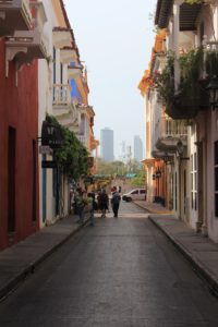
Cartagena in Columbia was our next port stop. This is our only stopover in Columbia so we were literally only getting a taster for a visit. Cartagena is on the north coast of Columbia and shares borders with Venezuela, Brazil, Ecuador, Peru and Panama. Being fairly undecided what to actually do for our day in Cartagena we booked ourselves onto a Colonial Sightseeing tour which took us into the old city. The old city is a World Heritage Site and is surrounded by a wall. It has been excellently preserved and restored with narrow cobbled streets and Spanish Colonial buildings. Areas we visited were El Centro where most of the historical buildings were located, the Inquisition Museum and the Plaza de los Coaches where they used to bring slaves to buy and sell. There were also the obligatory churches to visit as well. Columbia is where most of the world’s emeralds come from so as emeralds are also Kaye’s birthstone I got given the order to negotiate and buy – which I obviously did. So after coming out a lot lighter in the wallet we continued on with our tour. One thing about the old city was it was extremely hot inside it. The old walls surrounding the city do keep a lot of breeze out which made a humid day even hotter. The air conditioned coach drive back to the ship was very enjoyable. When we got back to the port we went for a short walk to the port entrance where they had some displays set up for the tourist. The exotic birds on display were absolutely stunning and colourful. It really did make a good day out even better. Most of the birds are just in the open and free to fly around though I imagine there a plenty of reasons they stay put with all the tourists feeding them every day.
Looking towards the Old City entrance
Entry sign to the Old City
The unique and old street signs
Plaza de los Coaches where they used to bring the slaves and sell them
Plaza de los Coaches where they used to bring the slaves and sell them
Plaza de los Coaches where they used to bring the slaves and sell them
Every street was a photo opportunity
Every street was a photo opportunity
Every street was a photo opportunity
The unique and old street signs
They also have a best balcony garden competition each year
They also have a best balcony garden competition each year
They also have a best balcony garden competition each year
They also have a best balcony garden competition each year
Great character in old doors
In the Inquisition Museum
In the Inquisition Museum
In the Inquisition Museum
Someone looking like they can read Spanish
The old buildings are pretty amazing – lucky to have so much history
We only had a day of sea time to recover before the next island and the port of Curacao. Curacao is in the southern Caribbean Sea and is the largest of what they call the three ABC Islands, Aruba, Bonaire and Curacao. The Dutch have had a very large influence on the island and this is really evident in the style of buildings that are on the island. Also, you get a very cosmopolitan feeling on the island as you walk around. We booked a tour that took us to the historic Hato Caves and finished off with a walking tour of Willemstad which is old historical downtown area of Curacao. The Hato Caves were once a hiding place for slaves on the island. The walk through the caves is well set up and with the history from the tour guide was a worthy visit. From the caves we drove on around the island and got dropped off at Willemstad for our walking tour. The only downside for us during this tour was that it was Sunday and most shops were closed. There were a few tourist shops and restaurants open but that was all. It was a very clean city centre to tour and with all the brightly coloured Dutch influenced buildings, also very quaint. The floating market wasn’t what we were expecting to see, when we were told about it we did picture something like in Asia but it wasn’t quite like that. It was still nice and an enjoyable part of the tour though not very big. The Queen Emma Bridge was very unique and different. This was built in 1888 and is supported by 16 pontoons. It pivots/swings from one end while the other end has a motorised hut/pontoon that goes forward to open and reverses to close. The island also has eight forts on it and the most famous is Fort Amsterdam which is in Willemstad and originally guarded the entrance to the harbour. We had a great lunch overlooking the harbour and taking in all the sites of the city. Curacao was one of the nicer islands we have visited so far on the trip and it would have been nice to stay a little bit longer.
Welcome to Curacao
There is a real Dutch influence in the buildings
There is a real Dutch influence in the buildings
Cave of Hato
Hato Caves
Hato Caves
Hato Caves
Hato Caves
One of the scary cave monsters
Curacao was covered in all these cactuses in the uninhabited areas
What you see lots of in Curacao and South America – Iguana’s
Looking towards Willemstad
Old churches are everywhere
Part of Fort Amsterdam that has been refurbished for private use
Willemstad
Willemstad streets
Willemstad streets
Willemstad Buildings – colourful and heavily Dutch influenced
Lots of Caribbean colour everywhere
Willemstad Harbour
Willemstad Harbour
Queen Emma Bridge with the motorised pontoon to open and close it
With only a day at sea to recover the next stop was Barbados and the capital Bridgetown. Barbados has a population of over 300,000 and it seemed a lot busier than what that number suggested. We spent the morning just doing our own thing around Bridgetown taking in some of the city. The port was only a short 15 minute walk from the city centre which was nice for a change and it was a pleasant easy walk into the town centre. Bridgetown was the only place out of continental USA the George Washington ever made to for any history buffs out there. For the afternoon, we had booked ourselves onto a guided photography tour and scenic drive. This was an escorted tour with a local photographer around the island and he also explained basic principles in taking photos. Unfortunately for me even with an expert on the tour my photography skills are not all that much improved. The tour did take you off the beaten path slightly as you did visit a few places that most tours do not go to. We drove to an area called the Scotland District which is known as the highlands of Barbados and then stopped at Barclay Park that overlooked the Atlantic Ocean on the east side of Barbados. A visit to the small fishing village of Bathsheba and a stop off at the local rum hut was pretty good as well. We sampled their local rum punch which I found very moorish and tasty. Bathsheba is well known for its rugged coastline that has very rugged rock formations jutting from the constantly pounding surf. We both enjoyed the drive around Barbados and the tour finished off an excellent day ashore.
Bridgetown Barbados
Parliament House near the Garrison Historic Area
Lots of nice canals in Bridgetown
Historic archway in the Garrison Historic Area
Independence Monument
Great old character buildings everywhere
There were lots of people everywhere just walking around
Great old character buildings everywhere
Some stunning driveways into plantations
Some stunning driveways into plantations
Old traditional character houses are getting rarer in Barbados
Old traditional character houses are getting rarer in Barbados
Old traditional character houses are getting rarer in Barbados
After a picturesque departure from Salvador it was a day at sea then the port city of Fortaleza and our last stopover in Brazil. Fortaleza is Brazil’s fifth largest city with just over 2.6 million people. One thing you do notice is the large amount of high rise apartment buildings in the city. Fortaleza is the capital of Ceara State but mainly experienced its growth late when it started to become a popular Brazilian tourist destination due to its climate. The day we were in port most of the city was closed due to the carnival celebrations going on. It was also a very wet day in Fortaleza and the rain pretty well stayed around all day. We didn’t have a tour booked for Fortaleza and in hindsight maybe we should have with the weather being as it was. What we did see of Fortaleza it did look quite run down and I think that was a good indication of the economy of the place. Most streets were in very bad condition and the favelas were more evident all around the city than in other places we had visited. As there wasn’t much open in the city to look at, not even bars or restaurants, we only spent a few hours on shore then went back to the ship. This is our last port in Brazil before three days at sea then Barbados. We enjoyed what we saw in Brazil a lot, though with our visit coinciding with carnival celebrations some of the places we saw weren’t at their best, unless you were here for the carnivals that is.
Fortaleza skyline
Lots of apartment buildings near the beach
Here comes the rain
We couldn’t even see the Fortaleza skyline – stayed like this for most of the day
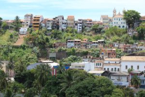
From Rio, it was a day at sea then the city of Salvador. Salvador is the capital of the Brazilian state of Bahia and is a very picturesque city to sail into. Salvador is also known for hosting one of the world’s biggest street carnivals during Brazil’s carnival week with up to two million people enjoying the week long party. We were not able to see any of the carnival celebrations as we were only in ports for the day and leaving before dark which was a pity but that’s part of the travelling bug bears. Salvador does have a fantastic historical centre that was an easy walk from the port to the centre. All the buildings in this area are brightly decorated and all the streets are cobblestones. The atmosphere of the whole area was very vibrant and busy. They were all getting ready for the carnival parade while we were there so it was a pity we missed it. Maybe one day we will make it back to see some of the carnival celebrations in Rio. We had a great seafood lunch in a local restaurant that helped to add to a great day in Salvador.
Salvador from the ship
Salvador from the ship
The funicular tracks up to the old city
On the funicular
The funicular – costs only about 10 cents for a ride
The historical old centre of Salvador – very colourful and vibrant
The historical old centre of Salvador – very colourful and vibrant
The historical old centre of Salvador – very colourful and vibrant
Great old architecture in Salvador’s old quarter
Great old architecture in Salvador’s old quarter
Great old architecture in Salvador’s old quarter
Lots of cobbled streets add to the character
Colourful statues for the carnival
Great old architecture in Salvador’s old quarter
Great old architecture in Salvador’s old quarter
Great old style charm everywhere
Great old architecture in Salvador’s old quarter
Colourful themes on lots of buildings
The Elevador Lacerda built in 1873
Mercado Modelo
Mercado Modelo
This is apparently a very nice alcoholic drink – makes you walk sideways after a few sips
From Foz do Iguacu it was a two hour flight to Rio De Janeiro and meet back up with the ship. I had a good flight but Kaye had the opposite. Kaye picked up a flu bug from somewhere and it seemed to hit her really bad in the plane. After landing in Rio and collecting our bags it was back to the ship and getting Kaye into bed. The ship was in Rio for two days and we had a tour booked on day two of the city and a visit to Christ the Redeemer Statue. The next morning Kaye was feeling even worse so that was my cue to get out before I got given any girl germs. It also meant that by Kaye not coming on the tour I got to have two seats to myself on the bus, at least one of us was having a good time. The tour travelled through the downtown area of Rio till we got to the train that takes you up through the Tijuca Forest to the summit Coronado Mountain where Christ the Redeemer is. When you get to the summit you can either que up for the lift or take the 220 steps to the top. One look at the que for the lift and the steps were the better option. You also get some pretty awesome views of Rio from here as well. we were told to watch out for pick pockets etc at this tour stop but no-one on or tour noticed or lost anything. With the amount of tourists there you would think that maybe something would happen. After an hour the bus then took us back past Rio’s iconic Ipanema and Copacabana beaches that both looked very nice but unfortunately there was no time to stop and test the water. Just have to come back another time.
Going through Rio on our tour to Christ the Redeemer
Going through Rio on our tour to Christ the Redeemer
Going through Rio on our tour to Christ the Redeemer
Train going through the Tijuca Forest on the way to Christ the Redeemer
Great views
Christ the Redeemer
Christ the Redeemer
Lots of tourists
Lots of tourists
Christ the Redeemer
Christ the Redeemer
Stunning views
Ipanema Beach
Copacabana Beach
Copacabana Beach
Copacabana Beach
Roads of Rio
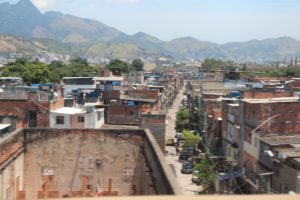
Some of the favelas of Rio
Rio Streets
Leaving Rio harbour
Brazil does have an aircraft carrier – no aircraft to be seen though
Farewell Rio – Christ the Redeemer on top of the mountain